


Bird’s Eye View Rendering Services | Studio3 Pakistan
Bird’s Eye View Rendering: How Architects and Developers in Pakistan Can Win Projects Faster
You can spend hours in a client meeting explaining where the park will be, how the towers will sit on the plot, and why the phasing makes sense — or you can show it all in a single image from above.
That single image is a bird’s eye view rendering. And in today’s competitive real estate and architecture landscape in Pakistan, it may be the most powerful visual tool you’re not fully using yet.
At Studio3, we create high-quality 3D architectural visualizations — including bird’s eye view renders — that help architects, developers, and builders communicate their projects clearly, win approvals faster, and sell before a single brick is laid.
What Is Bird’s Eye View Rendering?
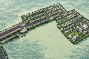
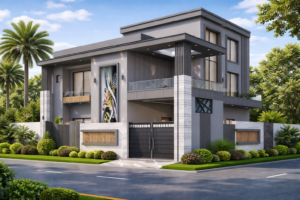
Bird’s eye view rendering is a type of 3D architectural visualization that presents a project from an elevated aerial perspective — as if seen from directly above or at a steep angle. It shows not just the building itself, but the full context: surrounding roads, green spaces, neighboring structures, zoning, and site layout.
Unlike a drone photograph, a rendering can show a project that doesn’t yet exist — with full photorealism, seasonal variations, and complete design intent.
There are two common projection styles:
- Orthographic (top-down): A straight overhead view, useful for site plans and zoning presentations.
- Axonometric / perspective aerial: A slightly angled, elevated view that shows height, depth, and building character more naturally.
Both are widely used in architectural presentations, real estate marketing, and planning approvals.
Why Bird’s Eye View Rendering Matters for Pakistani Developers and Architects
Pakistan’s real estate and construction sector is growing rapidly — from large housing societies in Lahore and Islamabad to high-rise developments in Karachi and mixed-use projects across tier-2 cities. In this environment, clarity wins.
Here’s where bird’s eye view rendering makes a direct impact:
1. Winning Investor Confidence
Investors and financiers don’t commit to what they can’t visualize. A bird’s eye render gives them the full picture: how the land is used, how phases connect, how the project fits within its surroundings. This spatial clarity reduces perceived risk and accelerates buy-in.
2. Supporting Regulatory and Planning Approvals
Local development authorities and planning boards need to assess how a project integrates with existing infrastructure — traffic flow, green coverage, building heights, and plot coverage ratios. A precise aerial rendering communicates all of this in one image, reducing back-and-forth and speeding up approval timelines.
3. Pre-Sales and Off-Plan Marketing
In Pakistan, off-plan sales are common — buyers commit before construction. A well-crafted bird’s eye render showing the full community, unit clusters, amenities, and landscaping builds trust and drives conversions. When buyers can see where they’ll live, they decide faster.
4. Architectural Competitions and Presentations
For architects entering design competitions or presenting to high-profile clients, bird’s eye visualizations demonstrate not just design skill, but strategic thinking. They show the project as a complete system — not just a building.
What a Bird’s Eye View Rendering Shows
A quality aerial render from Studio3 typically includes:
- Full site layout — buildings, roads, paths, parking, and landscaping
- Contextual surroundings — neighboring plots, streets, and urban fabric
- Phase visualization — showing development stages across time
- Vegetation and greenery — trees, parks, water features
- Realistic lighting — time-of-day and seasonal conditions
- Infrastructure — access points, utilities, and transport links
Every element is modeled to match your design intent — from overall massing to fine architectural detailing.
How It Fits With Other Visualization Types
Bird’s eye rendering is most powerful when used as part of a complete visualization strategy. At Studio3, we often pair aerial renders with:
- 3D Exterior Rendering — for façade detail, materiality, and street-level character
- 3D Floor Plan Rendering — to ground the aerial view in interior logic
- 3D Walkthrough Animation — to show movement and experience through the project
- Site Plan Rendering — for masterplans, townships, and phased developments
Together, these formats build a full visual narrative — from the city scale down to the room level.
Bird’s Eye View Rendering for Housing Societies and Township Projects
In Pakistan’s housing society market — whether DHA-style layouts, private gated communities, or government schemes — bird’s eye rendering has become almost standard for marketing and approvals.
Developers use aerial renders to show:
- Total plot coverage and density
- Green belts, parks, and open spaces
- Community amenities (mosques, schools, commercial zones)
- Phase 1 vs future phase delineation
- Relationship to main roads and transport links
This is where Studio3’s expertise is especially valuable. We understand the local real estate context and create renders that speak directly to Pakistani buyers, investors, and planning bodies.
The Studio3 Process: From Drawings to Aerial Render
Getting a bird’s eye view render from Studio3 is straightforward:
- Share your drawings — AutoCAD files, SketchUp models, PDFs, or even hand sketches
- Brief and reference — tell us the atmosphere, season, time of day, and key focal points
- First draft review — we deliver an initial render for feedback
- Revisions — we refine based on your input
- Final delivery — high-resolution files ready for presentations, print, and digital marketing
We work with architects, developers, real estate agencies, and government bodies across Pakistan.
Frequently Asked Questions
What’s the difference between bird’s eye view rendering and an aerial drone shot?
A drone photograph shows what already exists. A bird’s eye view rendering shows what will exist — before construction begins — with full design precision and photorealism.
How long does a bird’s eye view render take?
For a standard project, delivery is typically 5–10 business days. Complex township projects may take longer. Rush delivery is available on request.
What files do I need to share with Studio3?
AutoCAD drawings, SketchUp models, or even PDFs and hand sketches are all workable starting points. The more detail you provide, the more accurate the render.
Can Studio3 show phased development in a single render?
Yes. We can illustrate different development phases within one image, clearly distinguishing completed and planned areas.
How much does a bird’s eye view render cost in Pakistan?
Pricing depends on project complexity, scale, and level of detail. Contact Studio3 for a custom quote based on your specific requirements.
Ready to Show Your Project From Above?
If you’re an architect, developer, or builder in Pakistan looking to present your project with maximum clarity and impact, Studio3 is ready to help.
Contact Studio3 today, and let’s turn your plans into a compelling aerial visualization.
📍 studio3.pk | Professional 3D Architectural Visualization Services in Pakistan