


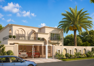
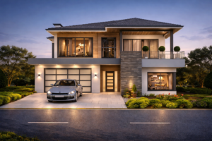
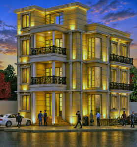
- 3d Exterior Rendering Services
- 3d Interior Design Rendering Services
- Aerial 3d Rendering Services
- 3d Floor Plan Design Services
- 3d Architectural Modeling Services
- Paper to CAD Conversion Services
- 3d Architectural Walkthrough Animation
- 3d Landscape Design Services
- 3d Commercial Real Estate Rendering Services
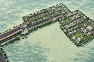
AERIAL 3D RENDERING SERVICES
See your entire project from above — photorealistic bird’s-eye views for housing societies, master plans, commercial developments, and urban projects across Pakistan.
Stats Row:
| 100+ | 5+ Years | 3–7 Days | Unlimited |
|---|---|---|---|
| Projects Delivered | Experience | Turnaround | Revisions |
Transform Architectural Plans into Photorealistic 3D Renderings — Fast.
Turn your architectural drawings and blueprints into high-impact, photorealistic 3D aerial renderings and bird’s-eye visualizations overnight. Our expert 3D architectural modeling and rendering team delivers stunning aerial 3D views that win client approvals, accelerate pre-sales, and bring your real estate development to life before construction begins.
Whether you need 3D exterior rendering, architectural walkthrough animation, or master-plan aerial visualization — Studio3.pk delivers with speed, precision, and photorealistic quality.
WHAT IS AERIAL 3D RENDERING?
Aerial 3D rendering — also known as bird’s-eye view rendering — is the creation of photorealistic visualizations of a property, building, or development as seen from above. Unlike standard exterior renders that show a building from street level, aerial renders capture the entire project from a high-angle or overhead perspective, showing the complete layout, site organization, surrounding roads, landscaping, and environmental context all at once.
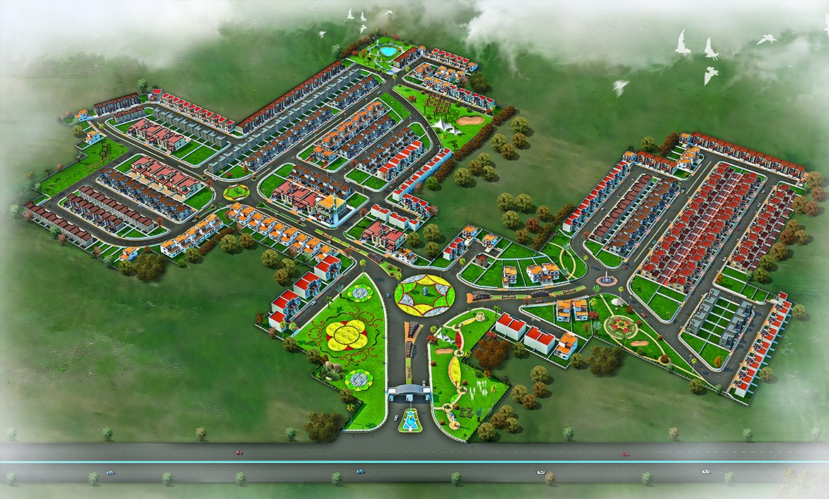
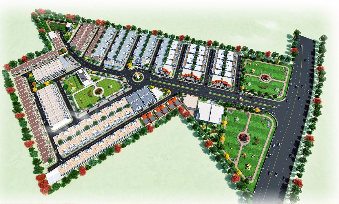
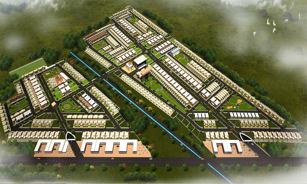
For large-scale developments such as housing societies, commercial complexes, and urban master plans, aerial rendering is often the most effective visualization tool available. It gives developers, investors, and approval committees a complete understanding of how a project is organized spatially — how buildings relate to each other, how roads and pathways connect, where parks and amenities are located, and how the development fits into its real-world surroundings.
In Pakistan’s rapidly growing real estate market, aerial renders are now standard in DHA, Bahria Town, and private housing society marketing — used in sales offices, billboards, brochures, and digital campaigns to give buyers confidence in a project before construction begins.
WHAT WE OFFER
| # | Service | Description |
|---|---|---|
| 1 | Housing Society Aerial Renders | Complete bird’s-eye views of residential housing schemes showing blocks, roads, parks, and amenities |
| 2 | Master Plan Visualization | Large-scale aerial renders of full development master plans for planning, approval, and investor presentations |
| 3 | Commercial Complex Aerial Views | Overhead renders of shopping centers, office parks, industrial zones, and mixed-use developments |
| 4 | Single Building Aerial Renders | High-angle aerial views of individual buildings showing rooftop design, site context, and surroundings |
| 5 | Day & Dusk Aerial Lighting | Multiple time-of-day lighting scenarios — daytime, golden hour, and evening — for the same aerial view |
| 6 | Aerial Animation Flyover | Animated aerial flythrough videos of your entire development — ideal for sales launches and investor events |
| 7 | Site Context Renders | Aerial views showing a project in its actual location with real surrounding roads, landmarks, and terrain |
| 8 | Print-Ready Marketing Renders | High-resolution aerial images sized for billboards, hoardings, brochures, and digital marketing campaigns |
PROJECT TYPES
Housing Societies & Gated Communities Full society aerial renders showing all residential blocks, commercial zones, parks, sports facilities, mosques, schools, and road network — the standard marketing visual for DHA, Bahria Town, and private housing schemes across Pakistan.
Commercial & Mixed-Use Developments Shopping malls, office towers, hotel complexes, and mixed-use developments shown from above — capturing the full scale of the project and its relationship with surrounding roads and infrastructure.
Urban Master Plans & Government Projects Large-scale urban planning renders for city development authorities, municipal governments, and institutional projects — covering entire zones, sectors, or districts in a single cohesive aerial view.
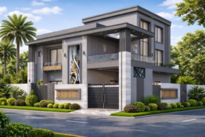
Individual Villas & Residential Plots High-angle aerial renders of single residential properties showing the building, boundary, garden, and site surroundings — increasingly popular for luxury villa marketing in Pakistan.
OUR PROCESS
01 — Brief & Consultation Share your site plan, master plan, CAD files, or architectural drawings. We discuss your preferred aerial angle, camera height, lighting scenario, and level of site detail required.
02 — 3D Site Modeling Our team builds a complete 3D model of your development — all buildings, roads, pathways, landscaping, parking zones, amenities, and surrounding context modeled to plan specifications.
03 — Camera Angle & Composition Multiple aerial camera angles are proposed for your review — overhead plan view, high-angle bird’s-eye, and intermediate perspective views — so you can select the composition that best represents your project.
04 — Rendering & Revisions Photorealistic renders are produced and shared for feedback. Lighting, materials, greenery, and surrounding environment are refined based on your input — unlimited revision rounds included.
05 — Final Delivery High-resolution aerial render files delivered in print and digital formats — ready for sales offices, billboards, brochures, websites, investor decks, and social media campaigns.
WHY CHOOSE STUDIO3 FOR AERIAL RENDERING?
Complete Project Communication An aerial render communicates what no street-level view can — the full scope, layout, and organization of your entire development in a single image. Essential for housing society sales, investor presentations, and approval submissions.
Photorealistic Quality Using Autodesk 3ds Max, Lumion, V-Ray, and SketchUp, Studio3 produces aerial renders with accurate scale, realistic landscaping, natural lighting, and surrounding environmental context — visuals that build real confidence.
Large-Scale Project Experience Studio3 has rendered full housing society master plans, commercial complexes, and urban development projects across Pakistan — we understand the scale, detail, and marketing requirements of large developments.
Fast Turnaround Standard aerial renders delivered in 3–7 business days depending on project scope. Rush delivery available. We keep your sales timeline moving.
Developer-Friendly Pricing Competitive Pakistan-market rates with transparent quotes. Bulk project packages available for developers requiring multiple views, animation, and full marketing visual suites.
Unlimited Revisions We work until you are 100% satisfied — multiple feedback rounds included in every project. Layout changes, landscaping updates, and lighting adjustments all accommodated.
CITIES SERVED
Lahore | Karachi | Islamabad | Rawalpindi | Multan | Faisalabad | Peshawar | Quetta | Gujranwala | Sialkot Hyderabad | Bahawalpur
DHA All Phases | Bahria Town All Cities | Government & Municipal Projects Nationwide
As a fully remote studio, Studio3 works with developers, architects, and planning authorities across all of Pakistan and internationally — no in-person meeting required to get started.
FREQUENTLY ASKED QUESTIONS
Q: What is aerial 3D rendering and why do developers use it? Aerial 3D rendering creates a photorealistic bird’s-eye view of a development — showing the entire project layout, buildings, roads, landscaping, and surroundings from above. Developers use it because a single aerial render communicates the complete scope and organization of a project in a way no street-level render can. It is the standard marketing visual for housing societies, commercial complexes, and master-planned developments in Pakistan.
Q: How is aerial rendering different from drone photography? Drone photography captures real images of an existing site. Aerial 3D rendering creates a photorealistic visualization of a project that does not yet exist — or shows a completed project from angles and heights a drone cannot safely reach. For pre-construction marketing, aerial rendering is the only option. For completed projects, renders can also show the future landscaped or developed state that is not yet visible on site.
Q: How much does aerial 3D rendering cost in Pakistan? Pricing depends on the size of the development, level of detail, number of views, and turnaround required. A single-building aerial render costs less than a full housing society master plan. Studio3 offers competitive Pakistan-market rates with transparent, upfront quotes. Contact us with your project details for a free, no-obligation quote.
Q: What files do I need to provide for an aerial rendering project? Site plan or master plan drawings — CAD files, AutoCAD DWG, or even a scaled PDF are all acceptable. Reference images of preferred architectural styles, landscaping, and surrounding area are very helpful. We can also work from basic layout sketches for early-stage projects.
Q: How long does an aerial 3D rendering project take? A single aerial render of a small-to-medium project is typically delivered in 3–5 business days. Large housing society master plans or full development renders may take 7–14 days depending on scope and detail level. Rush delivery is available. We provide a clear timeline after reviewing your brief.
Q: Can you render a full housing society master plan as an aerial view? Yes. This is one of Studio3’s core services. We regularly produce complete aerial renders of housing society master plans — showing all residential blocks, commercial zones, parks, sports facilities, mosques, schools, entry gates, and the full road network — at the level of detail required for sales office display, billboard hoardings, and investor presentations.
Q: Do you provide aerial flyover animation videos as well? Yes. In addition to still aerial renders, Studio3 produces aerial flythrough animation videos — a camera smoothly flying over and around your entire development. These are particularly effective for sales launch events, investor presentations, and social media marketing campaigns.
Q: Which cities and developers in Pakistan do you serve? Studio3 works with developers, architects, and housing authorities across all of Pakistan — including projects in Lahore, Karachi, Islamabad, Rawalpindi, Multan, Faisalabad, and all other major cities. We have experience with DHA, Bahria Town, and private housing society projects, as well as government and municipal development projects nationwide.